Alertes en vigueur Palmyra, GA
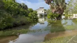
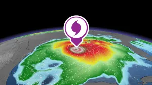
HLSTAEThis product covers eastern Florida panhandle, Florida Big Bend, southeastern Alabama and southwestern Georgia**TROPICAL STORM HELENE CONTINUES TO MOVE FURTHER AWAY. RESIDUALCOASTAL FLOODING AND OTHER BEACH HAZARDS COTINUE. **NEW INFORMATION---------------* CHANGES TO WATCHES AND WARNINGS:- All watches and warnings have been canceled* CURRENT WATCHES AND WARNINGS:- None* STORM INFORMATION:- About 360 miles north-northeast of Panama City or about 380miles north of Apalachicola- 35.1N 83.8W- Storm Intensity 45 mph- Movement North or 350 degrees at 32 mphSITUATION OVERVIEW------------------At 11 AM EDT, the center of Tropical Storm Helene was located about100 miles northeast. It is now moving to the north/north- northwest at32 mph. Conditions have improved this morning as Helene as moved out.While tropical storm force winds are now out of our of the region,breezy conditions still will stick around through the rest of themorning and into early afternoon. Additionally, tides still arerunning high and minor coastal flooding could stick around across theFlorida Panhandle and the northeast and eastern portions of theApalachee Bay through this afternoon and early evening.Rainfall from Helene has ended, and new flash flooding is notexpected. Ongoing flooding may take awhile to subside. Minor tomoderate riverine flooding will emerge and continue for days to come.Please do not drive through flooded roadways and stay out of floodwaters if at all possible. Flood waters may contain downed powerlines, dangerous wildlife, and other hazards.The tornado threat has passed.With widespread power outages across the region, please exercisecaution with cleanup efforts and use generators responsibly. Carbonmonoxide poisoning and/or death can result from generator misuse.Please do not return to evacuated areas until cleared by localofficials to do so. First responders are working as hard as they canto respond and restore services quickly and safely, and returning tooearly may hinder their efforts.POTENTIAL IMPACTS-----------------* OTHER COASTAL HAZARDS:Minor coastal flooding will be continue along much of the coast today.Large waves will be possible along the coast this afternoon.Dangerouns rip currents are expected through at least Saturday.PRECAUTIONARY/PREPAREDNESS ACTIONS----------------------------------* EVACUATIONS:Follow the advice of local officials* OTHER PREPAREDNESS INFORMATION:If your home or shelter was damaged, be alert to the smell of gasleaks and be cautious around electrical wiring, broken glass, jaggedmetal and wood, and protruding nails and screws.Do not attempt to return to evacuated areas until local authoritieshave inspected roads and bridges and have given the all clear.Hazards like downed power lines and trees, washed out roads,continued flooding in low lying areas and non-functioning trafficlights make travel difficult.Do not go sightseeing within impacted communities. Sightseersinterfere with the emergency work of first responders.When clearing out fallen trees, be careful with chainsaws and axes.Always wear protective gear and keep others at a safe distance.Leaning trees and those which have fallen on roofs or power lines canbe especially dangerous. If you are not in good health or unsureabout what you are doing, have someone with tree cutting experiencedo the job. Never cut trees without a partner.If using a generator, avoid carbon monoxide poisoning by followinginstructions provided by the manufacturer. Operate your generator ina well-ventilated space outside of your living area and away fromopen doors and windows.* ADDITIONAL SOURCES OF INFORMATION:- For information on appropriate preparations see ready.gov- For additional disaster preparedness information see redcross.orgNEXT UPDATE-----------As it pertains to this event...this will be the last local statementissued by the National Weather Service in Tallahassee FL regardingthe effects of tropical cyclone hazards upon the area.